Cover image Copyright Garmin Inc.
Overview
Today we’re looking at the Garmin Monterra, sadly a unit that’s out of production but still very usable. Why the heck would I review something out of production? Well, if you’re an Android fanboy like me, and want to use apps on your GPS and sync data easily — there’s not much better of a unit out there. Sure, they had some issues when they first came out, but with the latest software they’re pretty solid.
I was skeptical. Damn skeptical. But after having an Android and using it for hunting, fishing, and navigating around the woods and sharing locations with my hunting buddies, I wanted to see if there was an Android based GPS. Something like a phone with an extended battery, built in camera, and no cellular modem to suck valuable battery life from the power hungry GPS. The Garmin Monterra had all of that, but at the same price that my dad spent for a GPS back in 1995 from the company that looked like it was the size of a brick! I couldn’t swallow a $650 price tag, even after looking at my credit card rewards points — (I think of that as ‘free money’ never use it for the necessities if you can help it) I saw that I might be able to get one used. That’s exactly what I did. I found a barely used Monterra for less than half of MSRP kicking around on eBay.
What I really wanted to get here was the ability to use topographic maps as well as high definition satellite imagery to inform where I was choosing to hunt and selection for places where I was going to site a stand. I recently started hunting my new state of Maryland and wanted to be as informed as possible with the highly competitive nature of hunting in a place where there wasn’t a whole lot of public land to go around. I do plenty of cyber scouting and pouring over maps before I go, but sometimes you’re nowhere near cell signal and the Google Maps App doesn’t always do what I want to do in offline mode.
Up Front
When it first came out, it got crap reviews. It was the first Garmin Android based device, and a noble effort in my opinion. There were some software bugs — like the electronic compass being off by as much as 15 degrees (!). That was unacceptable, and Garmin has since issued several software patches making things right. Garmin was making a retreat from the mobile phone market, and did what appeared to be — removing the cellular modem, changing the price marginally, and then marketing the same device as a GPS. Maybe they did right by their customer base here.
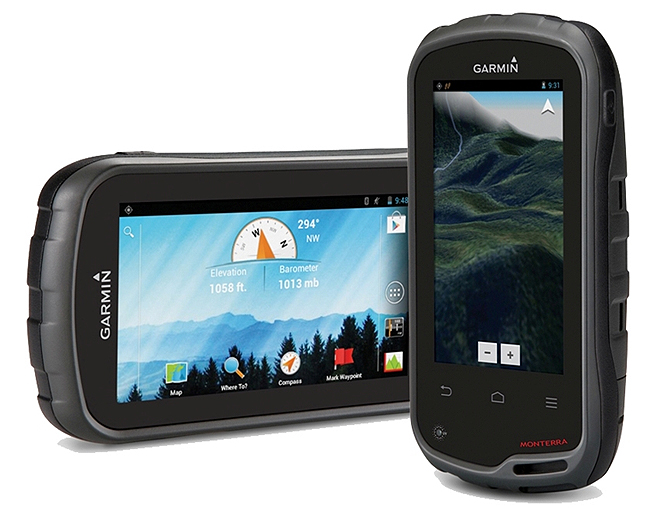
The Hardware
I can’t possibly do a better job than these guys on the actual hardware breakdown. They did an amazing write up on the unit years back.
The Hits
It runs Android 4.0.4 which seems ancient, but it’s new enough to run some really cool apps, and a lot of the gee-whiz features of later Android versions may adversely affect your battery life. I’m hoping that the Monterra doesn’t end up like my first “Smart TV” where LG decided to partner with Yahoo and no apps or features were ever developed past the 1.0 version.
Geotagging by default on photos. Be careful with this one. I use the high resolution camera to take pictures of potential tree stands or cool stuff I find in the woods (like old Jeeps!). It’s automatically geotagged using EXIF data embedded in the picture. That way when you download your photos you can overlay them on Google Maps or Google Earth or wherever. That’s pretty handy! However, it also means that if you take a picture of a gigantic black bear on your property and share it with your friend down the road, you’ve also just given them coordinates to your bear. Thankfully most modern social media sites strip the EXIF data for privacy’s sake — though if you’re a photographer or you want your data points for reference keep that in mind.
Built in weather radio. I know at least in our area NextRadio has been airing ads all over about modern phones having an AM/FM receiver on it. Guess what? This little guy is no different. It requires headphones, but the GPS can act as a weather radio in case of emergencies.
The Misses
With the extended lifespan battery it’s bulky. I usually throw it in my cargo pocket in my hiking pants or shorts when I’m hiking. I take the lanyard and affix it to my belt which hinders it from taking really nice photos but it ensures it doesn’t get lost.
E-mail? Okay, so it’s an Android device and it’s tied to your Google Account. But is there really no way to turn off email? Whenever I connect to Wifi to download offline maps or to update an App it always seems to sync with my Gmail account and download 700 new emails. Oh lord make it stop.
The maps that the Monterra ship with are not routable via roadways. So before you think that you’re fully replacing your TomTom or Android cell phone for GPS capabilities, it might be worth a pause. However, it might be worth noting that you can download an app like OpenStreetMaps and get some Android offline map navigation.
Garmin has said they won’t be delivering updates to the Android Operating System that runs on their hardware. What?
Overall
If you want a solid GPS from a company whose name you trust, your only hesitation should be the price tag. As I was thinking about this article and that I was reviewing a product that has been released for some time now I thought — is there really a huge use case for this? At least for me, yes. I was at the base of Old Rag mountain this year attempting to get signal on my cell phone to see where the heck I was. Sure, offline Google Maps would have worked, but I had both Sat maps, 24K Topos, and the default load on my Garmin Monterra. Not only did it and paper maps come to the rescue when my phone gave me the digital equivalent of a shrug, but I can also use this as the basis for the projects that will be forthcoming here on APT Outdoors.