EXIF data is data that’s embedded in every picture you take. It’s got information about what type of camera took the photo, if your phone has GPS it’s got that data in it, it can even have copyright information if you shoehorn it in there with software. It’s metadata — data about data!
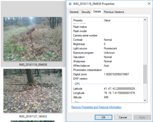
EXIF Data is embedded into the photo itself. From a GPS receiver the data is super accurate.
Whoa whoa whoa, hold the phone, GPS Data? Well sure. If it’s enabled, and you’re sharing your location data on your phone, handheld device, or baller GPS with a built in camera photos are automatically geotagged. That means that GPS data is embedded within the photo for later use. This can do anything from provide location data to Twitter and Facebook or allow you to take a look at your photos on a map at a later date. GPS also provides accurate timing data for your photos, allowing you to manage your photos at a later date. What we’re going to use it for is a little bit of hunting and fishing magic.
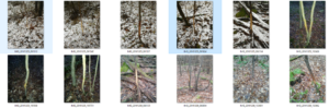
Here’s where I take a turn for the obsessive compulsive. If you’ve read Mapping Trophy Bucks by Brad Herndon you know that deer trails can be easily recognizable and that you can often predict travel lanes if you can learn key items like terrain features. When I’m out scouting, I take my Garmin Monterra and obsessively take pictures of rubs and scrapes. Why? Later I can take that information and inform my cyber scouting activities from year to year. From that information I can often suss out deer travel corridors. It means putting a lot of boot rubber to the mountainside, but consider it an investment for stand placement and knowing deer movement. After all, if you hunt from a tree stand, are you going to be willing to move it in the middle of the day if the conditions aren’t right for you?
I did say ‘a little obsessive compulsive’ didn’t I?
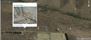
Now, I’m a Systems Administrator by trade, which means I’m lazy efficient. So what the heck do you do when you have a ton of photos you just took from a scouting outing, and now you need to have them mapped out for analysis? Don’t remember where that nondescript rub on that little sapling was as opposed to the other fifty photos you took? Fear not! Since I’m a systems admin, I did some work for you and wrote a little script. Just point it at your image directory, specify an output file name and go! It’ll rifle through all of your photos and it will take a look at the GPS metadata and map it on a KML file that can be pulled up in Google Earth for analysis.
Head over to my downloads section and get EXIF2KML, there’s only two arguments — ImgDir and KmlFileOut, one to where your photos are stored, and one to what you want to name your KML file when it’s done.
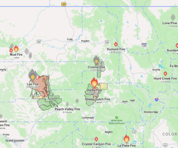
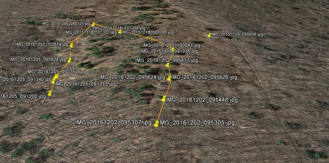
EXIF Data drives the GPS location for these pinpoints. Some are stand locations, some are rubs and scrapes.
Once you’ve got your KML file, open it in Google Earth and see if you can’t establish some trends. As I work on my scripts, I’ll be modifying my code to do things like predicting travel lines of whiletail deer — and one day doing things like mapping travel from identified food and bedding areas. These are some things with the right know how, you can do by hand. Check out the book I linked above for more information on how deer use terrain features to move, and couple that deadly knowledge with your geotagged photos — now I bet your Sunday morning coffee sessions will be a little more interesting.
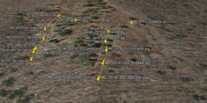
Using Google Earth it’s possible to correlate data from year to year with your pictures with GPS data embedded in EXIF.
What else can you do with EXIF Data? Do you have multiple trailcams set up? If your photos are labeled as to what trailcams took the photos, you can take the SD Cards from the trailcams, and a GPS Waypoint of where the camera was set up, and store the information in EXIF tags by using a piece of software to add geotagging. I’ve used Geosetter in the past, and it’s a pretty good representation of what is available to take photos and geotag them. Using those tags plus the time data that is already on the picture, the time in which the picture was taken, will allow you to further enrich your Google Earth scouting experience by allowing you to create a Google Earth Tour — showing you on a timeline when deer are traveling over your property. It’ll take some fiddling, but it is possible to group your rub lines like I show above, and then put a timeline and do a tour of deer showing up on your property. As I collect the data myself, I’ll post tutorials on how to build these tours and manipulate data sets of photos.
Now for every area that EXIF data is useful, there is also a dark side. Many image sharing sites will strip EXIF data from your photos for your safety, some sites have an opt-in for retaining EXIF data and keeping it attached to your photos. Why? The same GPS data that helped save forever where you got your trophy elk if shared on Facebook could lead other sleuthing hunters or poachers to your secret location. Think that’s not really a thing that can happen? It was pointed out that it’s already happened in Africa where poaching of elephants and rhinos for their ivory is still big business. Furthermore the US military has used EXIF data to enable strikes on ISIS fighters taking selfies. The data can be just that accurate. National Geographic was worried about it back in 2013. I’m not sure it’s a huge problem, but something you might want to take into account before you share images of your next catch or hunt.