State Interactive Maps
Want to get away, but have never hunted in the state before? Have you always suspected there’s another plot of public land just a little farther down the road? Or are you daydreaming of one day hearing the bugle of an elk call, but right now you can only think of the bugling from the kids down the hall? Look no further. I’ve compiled the best interactive maps from all fifty states. I’m constantly trying to keep this list up to date so that you can plan your hunts from the comfort of your chair. Some states don’t have interactive maps, or I was unable to find them at the time of this writing. For those states I’ve linked the more traditional PDF maps or georeferenced pdfs. Please confirm with the DNR in your hunting area to ensure that the lands are still open to hunting before setting foot out into a new piece of public land.
Quick Links:
AL | AK | AZ | AR | CA | CO | CT | DE | FL | GA
HI | ID | IL | IN | IA | KS | KY | LA | ME | MD
MA | MI | MN | MS | MO | MT | NE | NV | NH | NJ
NM | NY | NC | ND | OH | OK | OR | PA | RI | SC
SD | TN | TX | UT | VT | VA | WA | WV | WI | WY
Alabama
WMA of AL and MS
Wildlife Management Areas
Alaska
Arizona
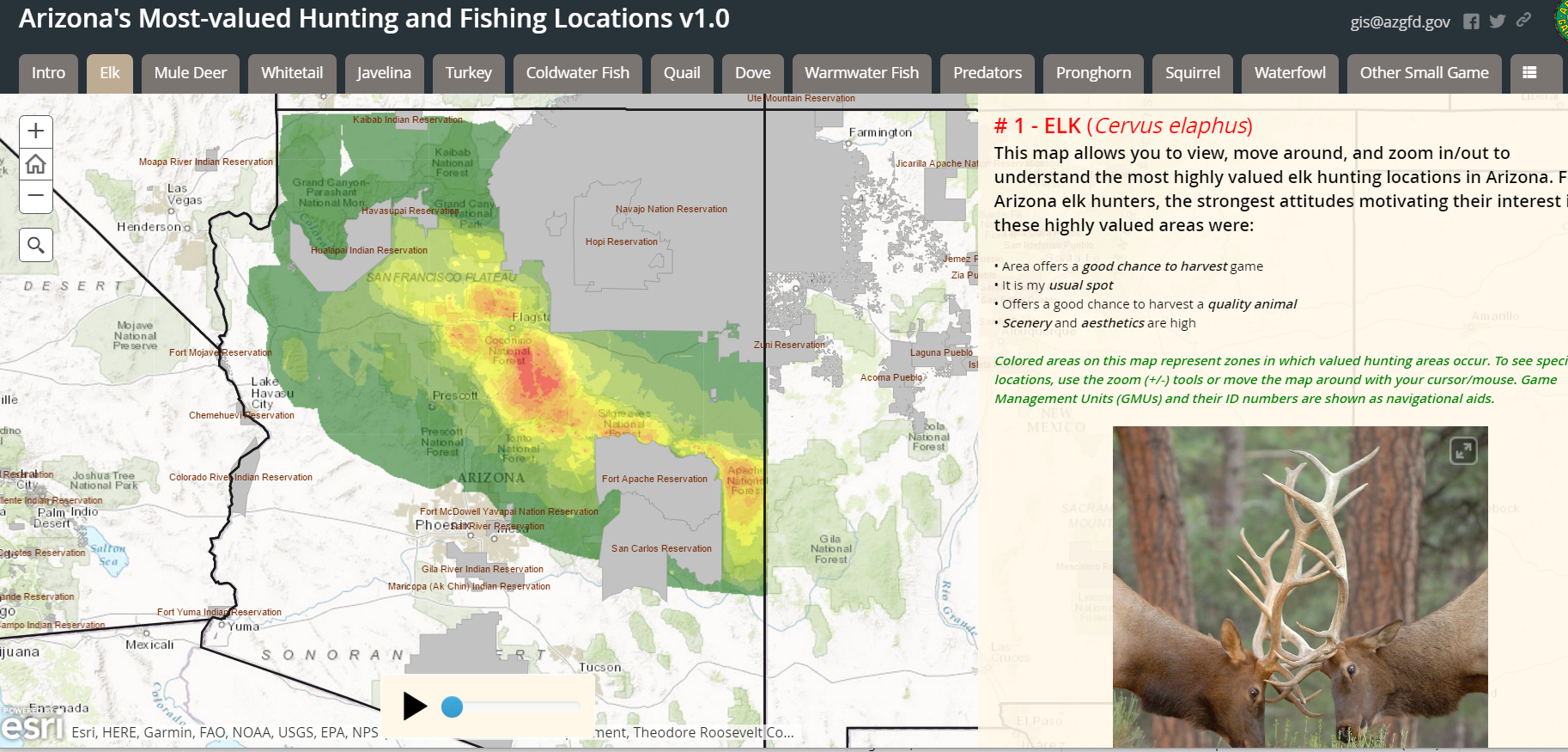
Arizona public land map
http://gis.azgfd.gov/
Map based on hunter survey results with heatmap!
http://azgfd.maps.arcgis.com/apps/MapSeries/index.html?appid=72ef284e22ab441b81c72472409c5d24&autoplay
Arkansas
WMA List
http://www.agfc.com/hunting/Pages/wmaList.aspx
https://gis.agfc.com/
California
Colorado
The Colorado Hunting Atlas
http://ndismaps.nrel.colostate.edu/index.html?app=HuntingAtlas
KMZ Boundaries for GMUs
http://cpw.state.co.us/learn/Pages/KMZ-Maps.aspx
More Outdoors Interactive Maps
http://cpw.state.co.us/learn/Pages/Maps.aspx
Connecticut
All Hunting Areas
http://www.depdata.ct.gov/wildlife/maps/huntingareas.asp
Delaware
Update 12/12/2020: Delaware now has a state interactive map broken down by counties here.
List of WMAs by county
http://www.eregulations.com/delaware/hunting/public-hunting-areas-county/
Individual PDF Maps
http://www.dnrec.delaware.gov/fw/hunting/pages/wildlifeareamaps.aspx
Florida
Couldn’t find any interactive maps.
Hunting zones listed
http://myfwc.com/hunting/season-dates/zone-map/
Georgia
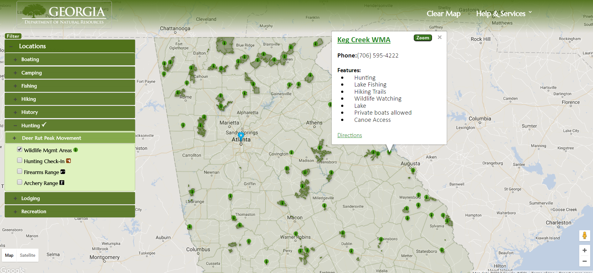
https://www.georgiaoutdoormap.com/
PDF Maps from this landing page
http://www.georgiawildlife.com/maps/hunting
Hawaii
ArcMap link here, but no data to speak of
http://histategis.maps.arcgis.com/home/webmap/viewer.html?useExisting=1
KMZ Files (Google Earth) available here
http://dlnr.hawaii.gov/recreation/hunting/
Idaho
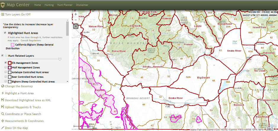
Fantastic layering to find specific game animals
https://fishandgame.idaho.gov/ifwis/huntplanner/mapcenter/
Illinois
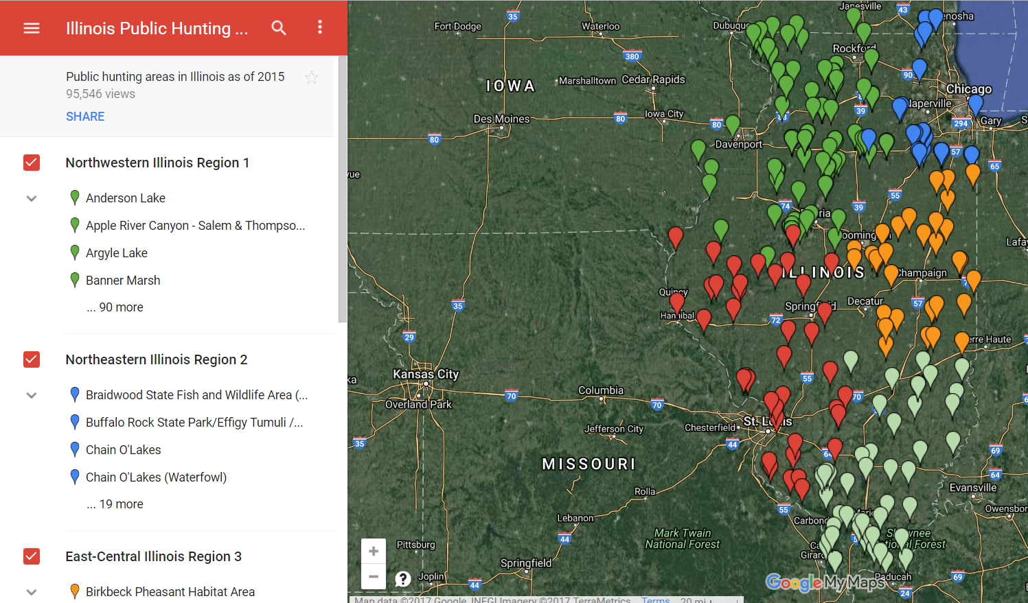
Engineered Pursuit — Looks like there’s someone else out there like me who hates wading through tons of pdf links and excel tables of WMAs
http://engineeredpursuit.com/illinois-public-hunting-areas/
Direct Link
Engineered Pursuit Illinois Google Maps
Indiana
Iowa
Kansas
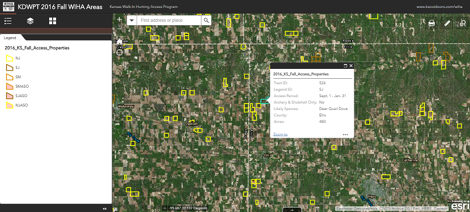
Kansas, you rock. You really embrace online and old school mapping
Fall WIHA Hunting Areas
Spring WIHA Hunting Areas
Garmin and Google Earth compatible KMLs
Kentucky
http://kygeonet.ky.gov/kdfwr/
Overview of hunting areas inside of Google Maps
Louisiana
Not really well integrated, but a good effort.
http://www.wlf.louisiana.gov/wma
Maine
http://www.maine.gov/dacf/mnap/assistance/conslands.htm
http://mainelakesandmountains.com/interactive-map/
Interactive ArcGIS Enabled Map… embedded as a frame, for less pixels!
http://www.maine.gov/dacf/parks/publications_maps/conservation_lands_maine.html
Really interesting feature to search for parks within one gas tank away. Kind of Interactive, but still have to search by activity
http://www.maine.gov/cgi-bin/online/doc/parksearch/index.pl
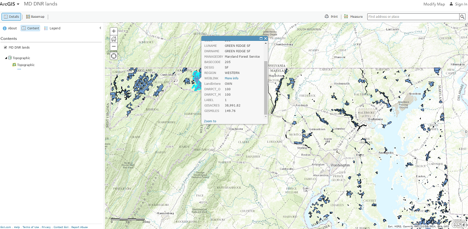
Maryland
Massachusetts
http://maps.env.state.ma.us/dfg/masswildlifelands/
Michigan
Woo, have to zoom in to make anything make sense, but they invested in their own little app. It takes some getting used to, but there’s a lot of pretty granular information there.
https://www.mcgi.state.mi.us/mi-hunt/
Minnesota
High Resolution LiDar based topo maps? Yes Please!
http://arcgis.dnr.state.mn.us/maps/mntopo/
Recreation Compass with hunting permit areas
http://dnr.state.mn.us/maps/compass.html
Traditional Maps — They list 1400 WMAs. Are you serious?!
http://www.dnr.state.mn.us/wmas/index.html
Walk In Access Program traditional maps
http://www.dnr.state.mn.us/walkin/index.html
Mississippi
Traditional Maps only
https://www.mdwfp.com/wildlife-hunting/wmas.aspx
Missouri
ArcGIS enabled public lands map
https://www.arcgis.com/home/webmap/viewer.html?webmap=485f10edf4e9498c843cfd9d3a2b8734
A More traditional “discover places” application
https://nature.mdc.mo.gov/discover-nature/places
Area Atlas
http://mdc7.mdc.mo.gov/applications/moatlas/AreaList.aspx
Montana
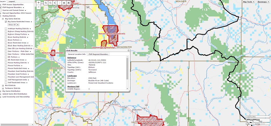
ArcGIS Map for WMAs
http://mtfwp.maps.arcgis.com/apps/webappviewer/index.html?id=3fd60e556e66465facb6965484224b1d
Centralized by species maps
http://fwp.mt.gov/hunting/planahunt/
The Hunt Planner application, suffers from being too busy when zoomed out, but it tightens up quickly and looks great.
http://fwp.mt.gov/gis/maps/huntPlanner/?
Traditional Maps including BLM
http://fwp.mt.gov/hunting/maps/
Nebraska
Public Access Atlas
https://maps.outdoornebraska.gov/PublicAccessAtlas/
Public Hunting Areas
https://maps.outdoornebraska.gov/hunting/
Nevada
Comment: I went to their official website where they claimed interactive mapping was coming online in 2013. Uh….
KML Maps per WMA
http://www.ndow.org/hunt/maps/
Pretty decent site for info, search by activity Hunting
http://publiclands.org/Get-Books-and-Maps.php?plicstate=NV
New Hampshire
http://granitviewii.sr.unh.edu/html5viewer/
http://www.wildlife.state.nh.us/maps/topo.html
New Jersey
Seems specific to deer hunting
http://www.state.nj.us/dep/fgw/ahrs_deer_viewer.htm
Intricate map of the zones themselves
https://sites.google.com/site/njhuntingmaps/home
New Mexico
New Mexico’s State Land Office has a pretty nice map
http://mapservice.nmstatelands.org/HuntingInformation/
They also have the CarryMaps Observer program, which I’ve not had a chance to really look at in depth
https://www.nm.blm.gov/huntingUnitMaps/mobileSite.html
New York
SLIM, the State Lands Interactive Mapper
DEC Maps on Google Earth
North Carolina
North Carolina Game Lands Map, selectable by species and facilities
https://ncpaws.org/wrcmapbook/
KMZ Files
http://www.ncwildlife.org/Hunting/Where-to-Hunt/Public-Places
North Dakota
PLOTS, Private Land Open To Sportsmen Interactive Map
http://gfapps.nd.gov/mobile/?viewer=plotsguidemv
Free Garmin map
https://gf.nd.gov/maps/gps
Ohio
DNR Lands through their GIS website
Areas themselves called out with pins, but no species info, just a link to another web page
http://wildlife.ohiodnr.gov/wildlifeareas
Oklahoma
ArcGIS Web Map, they loaded it with useful information like shooting ranges, boat ramps, WMA boundaries.
http://maps.wildlifedepartment.okstate.edu/publicapps/odwc_WMA_map/
Oregon
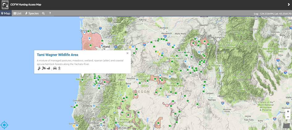
Awfully pretty as far as maps go. Choose Hunting or Shooting. The hunting map calls out specific types of game, and is easily filtered.
http://oregonhuntingmap.com/#/map
Looking for a specific type of biome in Oregon to hunt? This map has it.
Compass
Pennsylvania
This is what got me started on this kick, realizing my home state had an awesome interactive map!
http://www.gis.dcnr.state.pa.us/maps/index.html?dmap
Rhode Island
The official page on their DNR webpage 404s. That’s not good. I couldn’t find any interactive map but did find these pdfs:
http://www.rihunts.com/wma/
South Carolina
Public lands interactive map
SCDNR Public Lands Map
South Dakota
http://gfp.sd.gov/images/WebMaps/Viewer/WILMA/
Tennesee
ArcGIS Interactive map with boundaries of WMAs, several direct webpages linked when you click an WMA of interest.
http://twra.maps.arcgis.com/apps/webappviewer/index.html?id=953ef9d3bd044f9d9f0f9d7c0dd6b71c
Texas
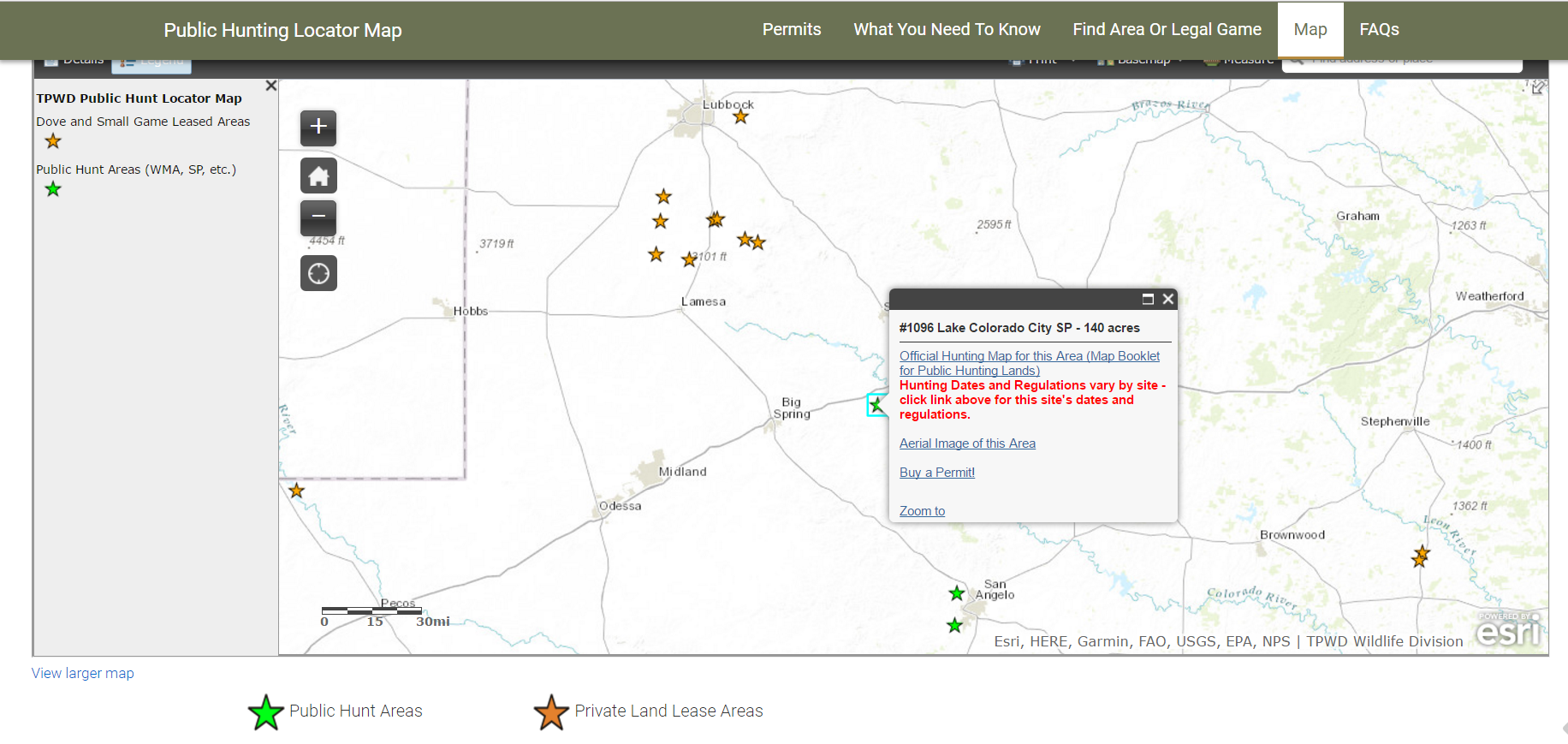
Specifically calls out dove and small game hunting leases and WMAs
http://tpwd.texas.gov/huntwild/hunt/public/lands/maps/
Utah
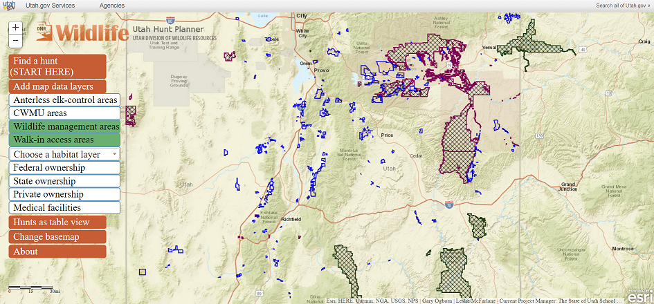
Utah Hunt Planner
https://dwrapps.utah.gov/huntboundary/hbstart
Their hunting search engine by game, weapon type, etc
https://wildlife.utah.gov/maps/public/search.php
Vermont
Comment: I didn’t specifically find an interactive map for hunting…
VT Map Viewer (requires MS Silverlight…)
http://maps.vermont.gov/vcgi/vtmapviewer/
Fishing access atlas
http://vtfishandwildlife.com/cms/One.aspx?portalId=73163&pageId=243390
Virginia
Their “Find Wildlife” Map
http://vafwis.dgif.virginia.gov/findwildlifeva/#/map
They have an ArcGIS Map that appears to have never been set up?
http://dgif-virginia.maps.arcgis.com/home/webmap/viewer.html?useExisting=1
Washington
They have their own GoHunt! Application that looks pretty well thought out. Search by species type, release sites for Pheasant stocking. There’s huge amounts of information here. This is a real standout. Acreage is counted, as is the permission type on Private/Public coops.
http://apps.wdfw.wa.gov/gohunt/
If only they did the same thing for fish… OH WAIT, they did.
http://apps.wdfw.wa.gov/salmonscape/map.html
West Virginia
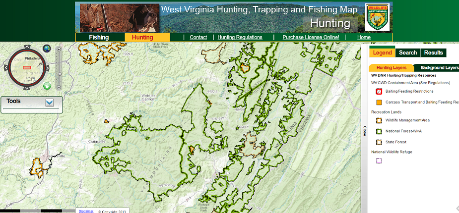
http://mapwv.gov/huntfish/
http://www.wvdnr.gov/map.asp
Wisconsin
Wyoming
Their maps are broken down by resident and non-resident as well as species. Here is non-res deer.
https://wgfd.wyo.gov/Hunting/Hunt-Planner/Deer-Hunting/Deer-Nonresident-Map
Here is where you can select other species
https://wgfd.wyo.gov/Hunting/Hunt-Planner

