As a follow-up to State Interactive Maps Part I I’ve been able to secure some more time and scour the web for even more interactive maps. Eventually I’ll be able to get them reviewed and posted up in our Resources section so you can easily find your state and review their maps and find a new adventure! So here goes, another 15 states!
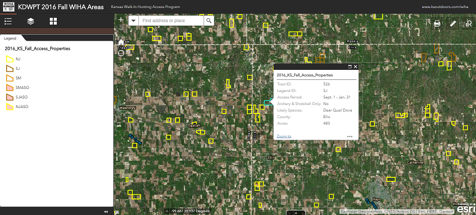
Kansas
Kansas, you rock. You really embrace online and old school mapping (The featured image above is Kansas’ Mapping tool)
Fall Hunting Atlas
Fall WIHA Hunting Areas
Spring WIHA Hunting Areas
Garmin and Google Earth compatible KMLs
Kentucky
http://kygeonet.ky.gov/kdfwr/
Overview of hunting areas inside of Google Maps
Louisiana
Not really well integrated, but a good effort.
http://www.wlf.louisiana.gov/wma
Maine
http://www.maine.gov/dacf/mnap/assistance/conslands.htm
http://mainelakesandmountains.com/interactive-map/
Interactive ArcGIS Enabled Map… embedded as a frame, for less pixels!
http://www.maine.gov/dacf/parks/publications_maps/conservation_lands_maine.html
Really interesting feature to search for parks within one gas tank away. Kind of Interactive, but still have to search by activity
http://www.maine.gov/cgi-bin/online/doc/parksearch/index.pl
Maryland
https://www.arcgis.com/home/webmap/viewer.html?useExisting=1&layers=a53c790198e644e192dc922183abf8aa
Massachusetts
http://maps.env.state.ma.us/dfg/masswildlifelands/
Michigan
Woo, have to zoom in to make anything make sense, but they invested in their own little app. It takes some getting used to, but there’s a lot of pretty granular information there.
https://www.mcgi.state.mi.us/mi-hunt/
Minnesota
High Resolution LiDar based topo maps? Yes Please!
http://arcgis.dnr.state.mn.us/maps/mntopo/
Recreation Compass with hunting permit areas
http://dnr.state.mn.us/maps/compass.html
Traditional Maps — They list 1400 WMAs. Are you serious?!
http://www.dnr.state.mn.us/wmas/index.html
Walk In Access Program traditional maps
http://www.dnr.state.mn.us/walkin/index.html
Mississippi
Traditional Maps only
https://www.mdwfp.com/wildlife-hunting/wmas.aspx
Missouri
ArcGIS enabled public lands map
https://www.arcgis.com/home/webmap/viewer.html?webmap=485f10edf4e9498c843cfd9d3a2b8734
A More traditional “discover places” application
https://nature.mdc.mo.gov/discover-nature/places
Area Atlas
http://mdc7.mdc.mo.gov/applications/moatlas/AreaList.aspx
Montana
ArcGIS Map for WMAs
http://mtfwp.maps.arcgis.com/apps/webappviewer/index.html?id=3fd60e556e66465facb6965484224b1d
Centralized by species maps
http://fwp.mt.gov/hunting/planahunt/
The Hunt Planner application, suffers from being too busy when zoomed out, but it tightens up quickly and looks great.
http://fwp.mt.gov/gis/maps/huntPlanner/?
Traditional Maps including BLM
http://fwp.mt.gov/hunting/maps/
Nebraska
Public Access Atlas
https://maps.outdoornebraska.gov/PublicAccessAtlas/
Public Hunting Areas
https://maps.outdoornebraska.gov/hunting/
Nevada
Comment: I went to their official website where they claimed interactive mapping was coming online in 2013. Uh….
KML Maps per WMA
http://www.ndow.org/hunt/maps/
Pretty decent site for info, search by activity Hunting
http://publiclands.org/Get-Books-and-Maps.php?plicstate=NV
New Hampshire
http://granitviewii.sr.unh.edu/html5viewer/
http://www.wildlife.state.nh.us/maps/topo.html
New Jersey
Seems specific to deer hunting
http://www.state.nj.us/dep/fgw/ahrs_deer_viewer.htm
Intricate map of the zones themselves
https://sites.google.com/site/njhuntingmaps/home